


THREE FREE TOOLS THAT WILL REVOLUTIONIZE PERMACULTURE LAND DESIGN
I’ve been teaching permaculture for the past decade, as I feel it’s one of the best ways to deal with the liabilities we’ve incurred collectively as a species. These problems include water shortages, floods, climate shifts, pollution, food insecurity, ocean dead zones, acidification – the list goes on and on. The following article is not about those liabilities, but rather their root cause. While it might be an oversimplification to say those liabilities can be solely attributed to one cause, it’s safe to say that all of these issues have one element in common: Water.
If you’re on this website, you likely have some familiarity with permaculture, which likely means you know that water is THE master element in any property design. The “Water, Access, Structures” mantra is a fundamental lesson in a Permaculture Design Course (PDC); recognizing this order of operation forever changed the way I thought about design. In short, all components on any property large or small either benefit from water or are damaged by water.
A FUNDAMENTAL MISUNDERSTANDING
Basically, if you understand how water interacts with the property, you can leverage this knowledge into designing systems that operate more effectively than most designed by present-day civilization. Misunderstand how water works, and you’ll end up creating liabilities and risks that manifest as what Bill Mollison coined as Type One errors. In modern society, these can be seen in the following scenarios:
- Designing cities to concentrate and dispose of water to protect poorly-placed infrastructure, leading to water shortage and floods.
- Placing buildings on floodplains, leading to loss of life, habitats, and the adaptive capacity of rivers to manage large energetic watershed events.
- Reducing complex ecologies to simple monocultures, altering how water interacts with the land and affecting the albedo.
- Lowering infiltration rates so that excess runoffs occur, creating climate shifts and diminishing the capacity of landscapes to handle dry and wet periods.
- Underestimating the erosive power of water, which leads to a misplacement of grain and tillage-based agriculture. Water hitting poorly sited fields carries away soil and applied agrochemicals into the ocean, creating vast polluted dead zones.
None of these decisions are made with malevolent intentions – they all stem from poor or uninformed designs. Climate shifts, topsoil loss, pollution, and a plethora of other issues can all be linked to a fundamental misunderstanding of hydrology. Water, when pacified, creates the conditions for life; when misunderstood, it causes destruction in its wake.
HOW TO READ THE LAND
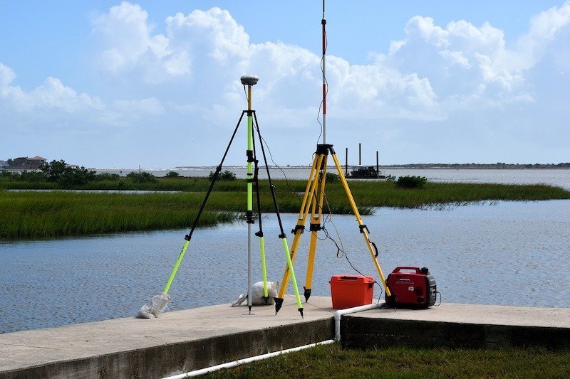
In permaculture and most land/water based professions (engineers, hydrologists, planners), contour maps are the primary tools for understanding how water interacts with a property. Permaculture aims to bring this understanding of contour maps – how to build them, read them, and make decisions based on them – down to a grassroots level. This knowledge is so vital that in the 72-hour PDC that we teach at Verge Permaculture, I dedicate an entire day teaching my students how to use transits, laser levels, A-frames, water levels, and eye levels so they can make maps wherever they might need to do design.
Unfortunately, this heavy focus doesn’t suit everyone. I sometimes have students who weren’t interested in learning surveying and mapping either because it didn’t play to their strengths. It bothered me that I didn’t have a mapping solution for those who don’t know how to survey that cost less than $1,500.
Until now.
OUR REVOLUTIONARY TOOLS FOR GOOGLE EARTH PRO
Based on over 20 years of combined engineering, farming, and permaculture consulting design experience, we recently developed & packaged three tools into a land design program called Adaptive Habitat Land Design. These tools leverage the incredible power of the free desktop program Google Earth Pro:
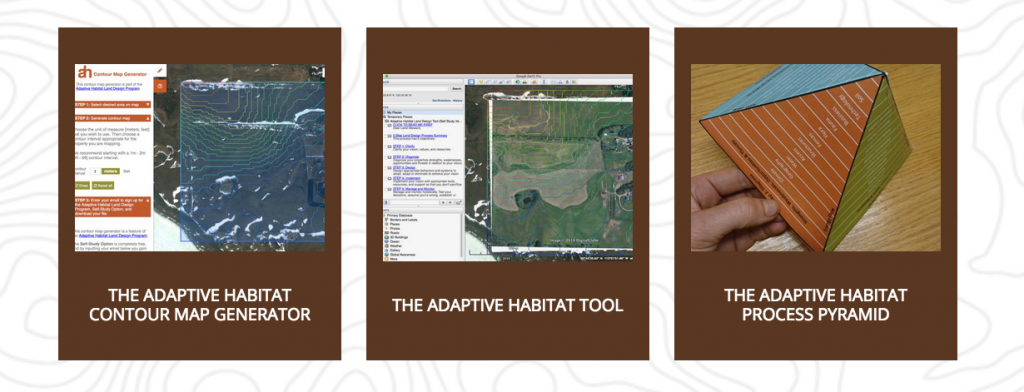
- The Adaptive Habitat Contour Map Generator allows you to generate a contour map file (KML) for anywhere in the world, in a format that can than be easily imported into Google Earth Pro.
- The Adaptive Habitat Tool is data management system that organizes information and offers a step-by-step workflow for the land design process directly in Google Earth Pro.
- The Adaptive Habitat Process Pyramid is a three dimensional model that illustrates our 5 step process for tackling the complexity of designing and managing land. It is a compilation of the most useful frameworks and heuristics we use in our daily work as consultants, educators, and land managers.
And yes, there is a paid version of the program, where my myself & Takota guide you through the design of your property. However, if you have DIY drive and motivation and if you’re clear that what you want isn’t a consultant, but the process and tools to bring your dream to life, The Self-Study Program (which is free) gives you nearly everything that we provide in our Guided Program… just no personalized hand-holding.
I believe these tools and this program is going to change the way people approach permaculture by removing some significant friction when it comes to designing land. The Adaptive Habitat Contour Map Generator democratizes global topographic information and allows designers to create the best possible design by removing the barriers associated with surveying. Our data information management tool for Google Earth Pro & our Process Pyramid then guide you, step-by-step, through the exact tested & proven process we use with our consulting clients.
Whether you’re looking to buy a property, design the one you have, or help others figure out their space, these tools (and this program) will help get you on your way.
Get started by generating a contour map for your property… and let us know what you think!


I have Google Earth Pro. Do I need Google Earth as well
Thanks for continuing to share great tools and insights! I appreciate it :)
Hiya,
I got it working simply by opening the kml (generated by selecting a box area and then activating the contour tool) file when Google Earth Pro is open. Just follow the instructions from their website. Once you have the kml file you can save it.
I’m getting an error message when I try to download it.
Hello,
If you have a sight or a scope with a lens or even a little triangle on a rod, or toy laser, you can add a 1 protractor to it and make a sextant, if you now you can make a tripod out of sticks or junk or even a photographers tripod, level it and use the scope you now how a theodolite,
Now you can set this over a mark and use a measuring tape to measure the distances and leap frog as you need, for magnetic directs a compass can be used or even the stars.
these methods are rough, farmers have used this to try and mark boundaries and have been accurate to with a couple metres.
Remember sin cos and tan, if you use right angles like the ancient Egyptians this will make calculations much easier. think x and y
alternatively instead of a measuring tape a disto could be used with a level and compass. which will make doing this easier.
Fair well and keep up the good work!